Petenwell
Flowage Map
This Petenwell Flowage area base map,
while representing the best information currently available to the
WRPCO, should not be relied upon
entirely by those using flowage waters and land for fishing, boating,
swimming, hiking and other recreational activities. Individuals must
use extreme caution because of the size, complexity, and constantly
changing conditions of Petenwell Flowage. The information on the map
is a composite of United States Coast and Geodetic Survey (USC&GS)
data and underwater contour data provided by the University of
Wisconsin-Stevens Point (UW-SP) and the Wisconsin Department of
Natural Resources (DNR).
Persons desiring more information or wishing to report particular
incidents or conditions observed on Petenwell Flowage may contact a
WRPCO representative at 1-800-53-WATCH.
Back to Top
Origins
The Petenwell Flowage consists of 23,040 acres and is the second
largest inland body of water in Wisconsin. It was built in the late
1940s for hydroelectric generation and flood control. The flowage is
on Wisconsin's Central plain or Central Sand, the ancient bed of
Glacial Lake Wisconsin that was a prehistoric one-million-acre body
of water.
Back to Top
Wisconsin River
The Wisconsin River is the hardest working river in the nation.
From its headwaters on the Wisconsin-Michigan border in Lac Vieux
Desert, it falls more than 1,000 feet on its 500-mile journey through
the state, before emptying into the Mississippi River at Prairie du
Chien.
Since the Ice Age, the mighty river has scoured gorges and cut great
rapids and waterfalls, whose roar has been replaced by the hum of
turbines and waterwheels at 26 hydroelectric dams. The energy generated
each year would supply the electrical needs of every home in Madison
for a year.
The Wisconsin, long notorious for devastating floods, is now
partially controlled by 21 reservoirs (flowages) on the river. Many
reservoirs are lowered prior to spring runoff in anticipation of high
water when spring breakup begins.
The Petenwell Dam and the Castle Rock Dam (its sister downriver) are
unique, because they are built on sand and were the first such projects
undertaken in the United States. The concrete dams are classified as
"floating-type construction" with imbedded cutoff walls that penetrate
deep into the glacial sands, permanently anchoring them.
Back to Top
Conditions Vary Greatly
Prior to construction of the Petenwell Dam, the lake bed was farmland,
prairie, and forested knolls and was bisected by the meandering Wisconsin
River. As with most flowages, Petenwell is relatively shallow and
quickly becomes turbulent on windy days. Bottom conditions and
depths vary considerably. Boaters are urged to become familiar with this
map before any activity on the flowage.
Back to Top
Open to the Public
Since flowage establishment, most of WRPCO's surrounding land has been
open to the public for hunting, fishing, hiking, nature observation,
skiing, and other recreational activities. Also, several 40-acre blocks
have been dedicated as school forests. The flowage's namesake, Petenwell
Rock, is just downriver from the dam and has been conveyed to the state
to ensure preservation as a geological landmark.
The power company has opened selected portions of its east dike to
public use for fishing, hiking, and nature observation, on a trial basis.
Hunting and trapping are not permitted. The area offers good views of the
flowage and some bank fishing. Located in Adams County in the Town of
Strongs Prairie, this area stretches north of Chicago Drive and east of
21st Avenue.
Parking for the east dike is available at the north end of 21st Avenue.
Absolutely no vehicular traffic is permitted on the dike system. Campfires
and overnight camping are also prohibited.
Persons who have special interests in visiting closed portions of the
dike system and related wildlife areas should contact WRPCO for more
information.
Back to Top
Wildlife Protection
Persons who have special interests in visiting closed portions of the
dike system and related wildlife areas should contact WRPCO for more
information.
Back to Top
Forest Management
Professional foresters manage forest land surrounding the Petenwell
Flowage for sustained timber production. More than 2,000 acres of marginal
farmland have been forested, and over two million trees have been planted.
Back to Top
Good Fishing Opportunities
The flowage offers some of the Wisconsin River's best fishing. Locally
known fishing "hot spots" include Devil's Elbow, the mouth of Fourteen
Mile Creek, Barnum Bay, and Strongs Prairie. These areas provide abundant
underwater structure and harbor good concentrations of fish.
Back to Top
Water Level Fluctuate
The primary purpose of the Petenwell Flowage is to store water that
creates a water head (height) to produce electricity as it passes (drops)
through the hydroturbines at the dam.
Flood control is another purpose. Flood control is accomplished by an
annual drawdown that begins in February. The drawdown can be as much as
five feet but is governed by the amount of water in the snowcover in the
state's northern section. The flowage is refilled as the snow melts,
normally beginning in late March. By May 1, the flowage must be full and
at normal summer levels. Between June 15 and December 31, the headwater
elevation fluctuation is limited to a maximum of one foot.
Back to Top
Federal License
The Petenwell Dam is operated by the WRPCO under licenses from the
FERC. The federal license provides control over flowage operations and
requires that the company outline an overall land use and recreation plan
that provides for full public utilization of the waters and land. The
current license expires on December 17, 2031.
Back to Top
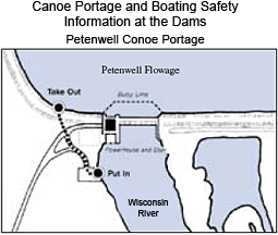
A flashing beacon is a warning that a flood gate is open. All
boaters should always stay at least 300 feet upstream from the dam. For
added safety, a restraining cable with orange floats and regulatory
warning buoys have been installed, as shown on the above drawing. The cable
is installed after spring breakup and is removed in late October. This
cable spans the upstream powerhouse intake area and the gate section.
Anchoring to the cable, except for emergencies, is prohibited.
Similar cable and floats have been installed just downstream from the
turbine discharge area. These hydro units are remote controlled and can
come on without warning. Safe boating procedures are a must, especially
near dams!
Similar cable and floats have been installed just downstream from the
turbine discharge area. These hydro units are remote controlled and can
come on without warning. Safe boating procedures are a must, especially
near dams!
Boaters may occasionally encounter floating debris from upriver or
which broke loose from the shoreline. If the debris poses a water hazard,
please mark it and notify a representative of the power company at
1-800-53-WATCH.
Back to Top